


Introduction
Walnut Creek is a city in Contra Costa County, California, located approximately 16 miles east of Oakland in the East Bay region of the San Francisco Bay Area. With a population of 70,127 as of the 2020 census, it serves as a major commercial and cultural hub for central Contra Costa County. Known for its vibrant downtown, world-class open space, and high quality of life, Walnut Creek has transformed dramatically from its origins as a rural crossroads into one of the Bay Area’s most desirable suburban communities. Its name derives from Arroyo de las Nueces—Spanish for “Stream of the Walnuts”—a reference to the native California walnut trees that once lined the creeks of the region.
Early History and Native Peoples
Long before European settlement, the land that would become Walnut Creek was home to the Bay Miwok people, who inhabited the region for thousands of years. Specifically, three distinct bands of the Bay Miwok lived in and around the Walnut Creek area: the Saclan, whose territory centered on the hills and valleys to the south and east; the Volvon (also known as Bolbon), who occupied the slopes of Mount Diablo and adjacent valleys; and the Tactan, whose lands stretched through the San Ramon Valley and into the Walnut Creek drainage. These groups lived in small semi-permanent villages, moving seasonally to take advantage of different food sources including acorns, seeds, fish, and game. The arrival of Spanish missionaries in the late 18th century brought devastating changes: forced relocation to Mission San José and Mission Dolores, introduced diseases, and the collapse of traditional lifeways. By the early 19th century, the Bay Miwok population in the region had been severely reduced.
Mexican Land Grant Era
Following Mexican independence from Spain in 1821, the Mexican government began issuing large land grants in Alta California to encourage settlement. In 1834, the Rancho Arroyo de Las Nueces y Bolbones was granted to Juana Sanchez de Pacheco, making it one of the earliest land grants in what is now Contra Costa County. The grant encompassed approximately 18,000 acres, stretching from the western slopes of Mount Diablo across the valleys and foothills to Suisun Bay. The name “Arroyo de las Nueces” came from the abundant native walnut trees (Juglans hindsii) that grew along the creek banks—a defining feature noted by early Spanish and Mexican explorers. Juana Sanchez de Pacheco was a prominent landowner and one of the few women to hold a rancho grant in her own name. After her death, the rancho was subdivided and sold, setting the stage for American settlement.
The Corners Settlement
With the California Gold Rush of 1849 came a wave of American settlers, and the area that would become Walnut Creek began to take shape as a small agricultural community. The first permanent American settler was William Slusher, who established a homestead along the creek in 1849. The settlement was originally known as “The Corners”—referring to the intersection of the two main roads running through the area: the road from Pacheco to the San Ramon Valley (today’s North Main Street) and the road from Oakland to the Mount Diablo foothills (today’s Ygnacio Valley Road/Mount Diablo Boulevard). In 1855, entrepreneur Milo Hough constructed the Walnut Creek House, a hotel and stagecoach stop that became the social and commercial heart of the settlement. The name “Walnut Creek” gradually replaced “The Corners” as the community’s identity. Hiram Penniman, an early surveyor and landowner, was instrumental in laying out the town’s initial grid and platting lots for development.
Railroads and Incorporation
Transportation was the catalyst that transformed Walnut Creek from a rural hamlet into a bona fide town. In 1891, the Southern Pacific Railroad extended its line through the San Ramon Valley, establishing a station at Walnut Creek that connected the community to Oakland, San Francisco, and the wider Bay Area. The railroad allowed local farmers to ship their produce—primarily walnuts, pears, grapes, and almonds—to distant markets with unprecedented speed. The Sacramento Northern Railway later added a second line, an electric interurban railway that ran through the heart of downtown, providing passenger service to Oakland and Sacramento. With growing population and commercial activity, Walnut Creek incorporated as a city on October 21, 1914, becoming the eighth incorporated city in Contra Costa County. At the time of incorporation, the city had only a few hundred residents, but the foundations for growth were firmly in place with rail infrastructure, agricultural wealth, and a strategic location at the crossroads of the region.
Modern Growth
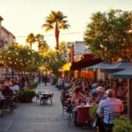
The mid-20th century marked Walnut Creek’s metamorphosis from a small agricultural town into a major suburban center. In 1951, the Broadway Shopping Center opened, becoming the first major retail development in all of Contra Costa County. This open-air shopping plaza attracted shoppers from across the region and established Walnut Creek as a retail destination. The opening of the Caldecott Tunnel’s third bore in 1964 and the construction of Interstate 680 further accelerated growth by dramatically reducing commute times to Oakland and San Francisco. The population exploded: from just 2,460 residents in 1950 to 9,903 in 1960, then to over 39,000 by 1970. By the 2020 census, Walnut Creek’s population reached 70,127. The downtown skyline transformed with office towers, luxury condominiums, and a thriving restaurant scene. Today, Walnut Creek anchors the I-680 corridor economy alongside neighboring Pleasant Hill and Concord, hosting corporate headquarters, a vibrant arts scene anchored by the Lesher Center for the Arts, and some of the region’s most sought-after residential neighborhoods.

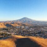
Open Space Legacy
Perhaps no aspect of Walnut Creek’s modern identity is more distinctive than its commitment to open space preservation. In 1974, visionary city leaders and residents passed a landmark bond measure that allocated funds for the acquisition and permanent protection of open space lands. This bold initiative, championed by local environmental advocates and community groups, resulted in the preservation of more than 1,800 acres of open space—including Shell Ridge Open Space, Lime Ridge Open Space, Acalanes Ridge, and the Sugarloaf Open Space. Walnut Creek today boasts the highest ratio of open space per capita of any city in California, a remarkable achievement for a community of 70,000 residents. The open space program continues to expand through partnerships with the Muir Heritage Land Trust and the East Bay Regional Park District. Over 32 miles of trails wind through oak-studded hillsides, grasslands, and riparian corridors, accessible directly from neighborhoods throughout the city. This legacy of conservation, born from a single bond measure nearly five decades ago, has become the defining feature of Walnut Creek’s character—a place where urban sophistication and wild California landscape exist side by side.