


Walnut Creek is home to more open space per capita than any other community in California — a distinction that didn’t happen by accident. While most residents know the Iron Horse Trail and the towering presence of Mount Diablo, two of the city’s most rewarding hiking destinations remain under the radar: Lime Ridge Open Space and Shell Ridge Open Space. Together, they represent nearly 2,000 acres of protected ridgelines, oak-studded hillsides, and panoramic views. Here’s everything you need to know to explore Walnut Creek’s hidden hiking gems.
The 1974 Open Space Bond: A Defining Moment
In 1974, Walnut Creek voters approved a $6.7 million bond measure to acquire open space, making the city one of the first in California to use municipal bonds specifically for land conservation. That vote set in motion the preservation of more than 1,800 acres of ridgelines, canyons, and oak woodlands that now ring the city’s edges. It was a forward-looking decision that shapes how Walnut Creek looks and feels today.
The bond’s legacy lives on through partnerships with agencies like the East Bay Regional Park District (EBRPD), Save Mount Diablo, and the John Muir Land Trust. These organizations have collectively protected thousands of additional acres, connecting Walnut Creek’s open spaces to the broader East Bay conservation network. Lime Ridge and Shell Ridge are two of the crown jewels of that effort.
Lime Ridge Open Space
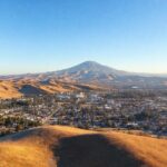
Lime Ridge is the northern sentinel of Walnut Creek’s open space system, a roughly 1,200-acre expanse of mixed grassland and oak woodland that rises between Ygnacio Valley Road and the Concord border. The name comes from the limestone deposits in the area’s geology, which color the exposed cliffs and outcroppings a distinctive pale gray.
The trail network at Lime Ridge is a mix of wide fire roads and narrow single-track, with most routes trending moderate in difficulty. The ridge itself runs roughly north-south, offering views that sweep from Mount Diablo in the east to the Carquinez Strait on clear days.
Lime Ridge connects directly to the Diablo Foothills Regional Park, part of the East Bay Regional Park District. This connectivity is no accident — conservation advocates worked for decades to stitch together a contiguous wildlife corridor from Walnut Creek into the Diablo foothills. Today, deer, coyotes, bobcats, and golden eagles move freely across lands that were once threatened by subdivision proposals.

Shell Ridge Open Space
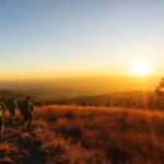
Shell Ridge covers approximately 800 acres on the southern edge of Walnut Creek, stretching east from the Borges Ranch area toward the Diablo foothills. The name references the marine fossils found throughout the ridge’s sedimentary rock — remnants of an ancient seabed that once covered much of what is now Contra Costa County.
Where Lime Ridge is broad and open, Shell Ridge feels more intimate. The trails wind through dense oak groves, past seasonal creeks, and up to ridgeline viewpoints that feel surprisingly remote given their proximity to suburban neighborhoods. The network connects to several other open spaces, including Acalanes Ridge and the Indian Valley area, creating a contiguous trail system that spans multiple municipalities.
Lime Ridge vs. Shell Ridge: At a Glance
| Feature | Lime Ridge | Shell Ridge |
|---|---|---|
| Acreage | ~1,200 acres | ~800 acres |
| Difficulty | Easy to moderate | Moderate |
| Best For | Families, panoramic views, wildflowers | Solitude, oak groves, geology |
| Landscape | Open grassland, limestone outcroppings | Oak woodland, sedimentary ridges |
| Connects to | Diablo Foothills Regional Park | Acalanes Ridge, Indian Valley |
| Wildlife | Golden eagles, deer, bobcats | Coyotes, hawks, wild turkeys |
| Peak Season | Spring (March–May) | Year-round |
Wildlife, Geology, and What You’ll See
Both open spaces are rich in wildlife. The oak woodlands support acorn woodpeckers, western bluebirds, and red-tailed hawks. Grassland areas are home to California ground squirrels and western fence lizards — keep an eye out for northern harriers hunting low over the fields in winter. Larger mammals like mule deer and coyotes are common at dawn and dusk; bobcats are present but far more elusive.
Geology enthusiasts will find Shell Ridge particularly rewarding. The sedimentary layers exposed along the ridgeline contain marine fossils from the Miocene epoch, roughly 10–15 million years ago, when much of California’s Central Valley was an inland sea. Lime Ridge’s limestone outcroppings tell a similar story, with fossilized shells occasionally visible in the exposed rock faces.
The East Bay Conservation Network
Walnut Creek’s open spaces don’t exist in isolation. They are part of a larger conservation story that spans the East Bay:
East Bay Regional Park District manages Diablo Foothills Regional Park, which connects directly to Lime Ridge. EBRPD is the largest regional park district in the United States, with 73 parks and more than 125,000 acres across Alameda and Contra Costa counties.
Save Mount Diablo has been protecting lands around the mountain since 1971, with a focus on creating a contiguous wildlife corridor from the Diablo range to the Suisun Bay. The organization has helped preserve more than 120,000 acres since its founding.
John Muir Land Trust protects 23 properties totaling more than 4,600 acres in Contra Costa and Alameda counties, including several parcels that connect to Walnut Creek’s open space network.
Seasonal Tips for Visiting
Spring (March–May): The prime season. Wildflowers blanket Lime Ridge’s grasslands — California poppies, lupines, and owl’s clover create a color show that peaks in April. Trails are in excellent condition after winter rains. Go early; parking fills on weekends.
Summer (June–September): Hills turn golden brown, but early-morning hikes are still pleasant. Bring water — there is no potable water at either open space. Rattlesnakes are more active; stay on trails and keep dogs leashed.
Fall (October–November): Cooler temperatures return, and the quality of light makes for spectacular views. Oak trees drop acorns, drawing woodpeckers and deer. An underrated season for photography.
Winter (December–February): Trails can be muddy after rain, but the hills turn green almost overnight. The crowds thin out significantly. After a storm, the clarity of the air means Mount Diablo and even the Sierra Nevada snowpack are visible from the ridges on clear days.
Getting There
Lime Ridge: The primary access point is at the end of Ygnacio Valley Road, near the Contra Costa Canal Trail. Additional trailheads exist off Treat Boulevard and Cowell Road. Parking is limited to small pullouts and neighborhood streets — arrive early on weekends.
Shell Ridge: Access via Borges Ranch (1035 Castle Rock Road), which has a small parking lot and serves as the most popular entry point. Additional access is available from Sutherland Drive and Marshall Drive trailheads. Borges Ranch itself is a historic working ranch dating to 1899 and worth a visit on its own.
A Legacy Worth Exploring
The 1974 bond measure was a bet on the future — a bet that Walnut Creek residents 50 years later would value open space more than the subdivisions that might have been built in its place. That bet paid off, and it paid off spectacularly. Lime Ridge and Shell Ridge are not just hiking destinations; they are living monuments to a community that chose preservation over development at a moment when the outcome was far from certain.
Next time you’re looking for a trail that doesn’t require driving to Mount Diablo or the Berkeley Hills, point yourself toward Lime Ridge or Shell Ridge. The views are closer than you think.