

WALNUT CREEK, CA — There’s a map somewhere between Walnut Creek and Pleasant Hill that shows exactly how many eyes are watching your commute. Not the kind of eyes that look back. Just the kind that log, store, and make everything searchable.
Walnut Creek has roughly forty Flock Safety automated license plate readers inside city limits. Contra Costa County has roughly three hundred. The cameras run 24/7, photograph every passing vehicle, and feed the data into a network that stretches across the state. The question isn’t whether they’re here anymore. The question is: do you know where they are?
The DeFlock interactive map at maps.deflock.org is the best public answer. It’s a volunteer-driven project that documents ALPR camera locations across the country, and for Walnut Creek, it’s been one of the few ways residents can see what’s been installed without waiting for a city council agenda. The map is live, regularly updated, and — as Flock Safety itself has argued — controversial. DeFlock maintains the public has a right to know where they’re being monitored. Flock Safety has tried to have it taken down. Neither side has won. The map is still there, still running, and still the best starting point.
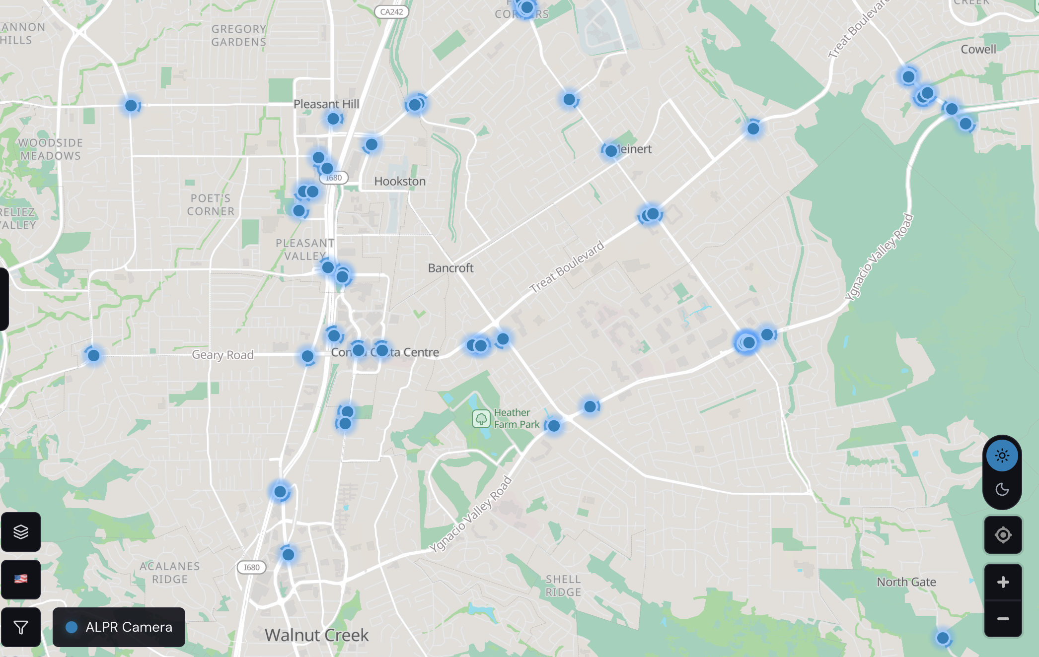
Zoom in on the map and the pattern becomes obvious. The blue dots cluster along the arteries: the I-680 interchanges where Treat Boulevard meets the freeway, the Ygnacio Valley Road corridor heading toward Concord, the Geary Road strip near Contra Costa Centre, the Bancroft and Oak Grove entries into downtown. They’re not random. They’re at the chokepoints — the roads where traffic funnels in and out, where a plate read can connect a vehicle to a crime hours later.
What each dot represents is worth understanding. Every Flock camera captures the license plate, the vehicle make, model, and color, a timestamp, a GPS coordinate, and distinguishing features like dents, roof racks, or bumper stickers. All of that becomes searchable data. An investigator can search for “a white Ford F-150 with a roof rack and a dent on the passenger door” and get results from across the entire network — not just Walnut Creek, but every camera in Contra Costa County, and potentially beyond.
The Quick Numbers
- Cameras in Walnut Creek: Approximately 40 (per WCPD estimates)
- Contra Costa County total: Roughly 300
- Data captured: Plate, make/model/color, timestamp, GPS, vehicle features
- Data retention: 30 days by default, then auto-deleted
- Network scope: Cross-jurisdictional; data searchable across agency lines
- Map source: maps.deflock.org (volunteer-maintained)
- WCPD non-emergency: (925) 935-6400
- Records bureau: (925) 943-5865
The DeFlock map is built from OpenStreetMap data, tagged with the brand “Flock Safety” where volunteers have confirmed installations. It’s not exhaustive — some cameras are privately owned by HOAs or businesses and don’t show up. Some are documented; some aren’t. But the pattern it reveals is real: Walnut Creek’s road network is heavily monitored, and the monitoring extends well beyond city limits into Pleasant Hill, Concord Centre, and the I-680 corridor.
That’s the part most people don’t think about until they’re looking for it. You drive from Ygnacio Valley to downtown, past three cameras on Treat, two on Geary, one near the Heather Farm Park ring. You make the trip to the grocery store on Oak Grove, past another cluster near the Bancroft intersection. You don’t notice. Neither does the camera — it just logs, and the data sits in a database waiting for someone to search it.
See It Yourself
Open the map in a new tab and zoom in on your commute route. Paste in your address, or just drag the view until you see Walnut Creek, Pleasant Hill, and the I-680 corridor. The blue dots are where volunteers have documented cameras. Each one is a device that photographs every vehicle that passes, day and night, and feeds the data into a searchable network that stretches across the state.
The map doesn’t tell you what was captured — that’s searchable only by law enforcement with a valid query — but it tells you where the eyes are. If you drive Treat Boulevard to work, you’re on a monitored corridor. Take the I-680 on-ramp near Ygnacio? Another cluster. Head downtown via Bancroft? Covered. The map doesn’t ask permission to show you this. It’s public data, documented by volunteers, maintained against Flock Safety’s objections, and accessible to anyone with a browser.
The Broader Debate
Walnut Creek isn’t alone in grappling with this. Across the East Bay, the conversation keeps moving. El Cerrito has been talking about removing its own Flock network. Brentwood is weighing rules for privately owned cameras. Oakland has used Flock data to track down sideshow suspects. The technology is embedded in law enforcement workflows, the investigative utility has been demonstrated, and the cost is manageable for agencies. But the friction points — transparency, cross-jurisdictional sharing, error rates, the warrant question — are the same everywhere.
The cameras don’t prevent crime. They don’t stop a car from speeding past them. What they do is create a searchable record of every vehicle that passes, 24/7, and make that record available to investigators across a multi-jurisdictional network. Whether that’s a net public good or a net privacy risk depends on which question you’re asking. The cameras watch the roads. The question that matters is whether anyone is watching the cameras.
What You Can Ask For
If you want to know more about what’s happening in your neighborhood, there are practical steps. California’s Public Records Act gives residents the right to request information about surveillance technology used by public agencies. Contact the Walnut Creek Police Department’s records bureau at (925) 943-5865 and ask for data-sharing policies, data retention periods, and access logs. City council meetings are another channel — decisions about whether to expand or renew ALPR contracts typically go through the council. Attending meetings or reviewing agendas at walnut-creek.org is one way to stay informed and make your voice heard.
The Bottom Line
What you can do now: Open the DeFlock map and zoom in on your commute. See where the blue dots are. If you want to know more about what that data means for privacy, read our explainer on how the cameras work. If you want to know whether they’re actually solving crimes, read our one-year data check. The cameras are here. The map is public. The conversation is yours.
Know something I should cover? Reply or DM.